


Annonse
New theory turns the layers beneath the seabed upside down
If this theory is correct, it could have consequences for CO2 storage.
Published
Layers upon layers of history spanning millions of years lies beneath the seabed.
The deeper you go, the older the sand, clay, or remains of organisms are that once lived in the ocean.
Geologists and engineers can thus read these layers as a timeline.

They can, for example, look for layers of sandstone. This porous rock might be filled with oil and gas. Or it could be used to store CO2.
But now two researchers have launched a new theory that turns some of those layers upside down.
Annonse
Liquid quicksand
The crux of the matter has been known for many years.
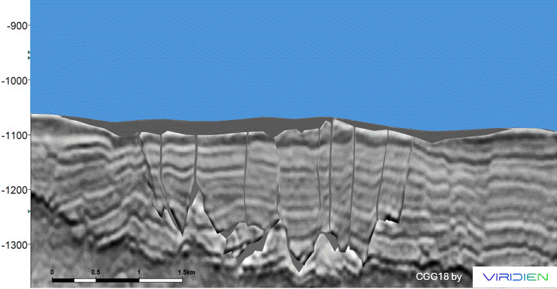
Seismic images of the seabed reveal that layers of sediment do not always lie neatly like a stack of pancakes.
Sometimes sandstone can cut vertically through another type of rock.
“Most people think that this is sandstone that was squeezed upwards,” says Philip Ringrose, professor of energy transition and geoscience at the Norwegian University of Science and Technology (NTNU), who was not involved in the new study.
Under high pressure, sandstone is transformed into liquid quicksand.
The prevailing theory has been that earthquakes have pushed quicksand upwards and into the fractured layer above.
But the new theory upends this explanation.
The layers have swapped places
Researchers Jan Erik Rudjord at Aker BP and Mads Huuse at Manchester University have published the new study in Communications Earth & Environment.
The researchers used 3D seismic images from the northern North Sea.
Most viewed
They came up with the new theory when they studied the layers of sand and clay that ended up on the seabed around 20 million years ago:
Some of the layers that are now buried 1,000 metres below the seabed have swapped places.
Like a meringue base cracking apart
Annonse
For those of us who rarely think about what has happened in the depths of the Earth's crust, a pavlova cake serves as a good analogy.
Vigorous shaking causes the brittle meringue to crack into many pieces.
Then the vanilla cream – which, for the sake of metaphor, becomes a little runnier – flows down through the cracks.
That cream ends up under the cake.
Then the lighter pieces of the meringue base are pushed up to the top of the cake, thereby switching places.
Some researchers will be a little sceptical
In the same way, earthquakes and the weight of the sand may have cracked open the porous claystone.
Younger sand on top may have been transformed into quicksand by the shaking. And sunk down into the cracks.
Then the heavier quicksand could have forced its way under the lighter clay and pushed it upwards.
Philip Ringrose finds the theory very interesting.

“It’s not an entirely new concept that sediments can move up and down, but it has never been seen on this scale before,” says the NTNU researcher.
Still, not everyone will agree with the interpretation, according to Ringrose.
“I think there will be some who will be a little sceptical that this could have happened on such a large scale and that there was both a sinking effect and a full inversion,” says Ringrose.
A feeling of having seen it before
Rudjord and Huuse, however, could not get any of the old theories to fit the seismic images.
“It was almost like intuition or a feeling that we’d seen this before,” says Rudjord.
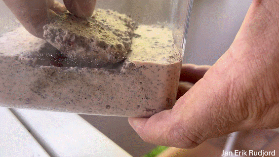
Rudjord was thinking of buoyancy. In other words, the physical forces that push something upwards.
Like ice cubes at the bottom of a glass that float to the top when you fill it with water.
“In many seismic images, it really does look as if something is floating,” he says.
Here he uses a simple experiment to demonstrate how something like this could have happened:
Found support in drill samples
The two researchers went looking for more clues to support the theory.
They found one such clue in drill samples from the area.
The Norwegian Petrolium Directorate (NPD) examined the age of the different layers in a 2018 report.
Remains of prehistoric shells can in fact be dated.
But several of the samples showed that the sand was younger than the layer above.
“The new model depends on the age relationship they see being real and not due to a glitch when the wells were drilled,” says Per Terje Osmundsen, a geology professor at NTNU.
The drilling itself may be to blame
In NPD's report, the drilling itself is blamed for the finding.
In other words, the drill might have dragged younger sediments downwards.
The authors of the new study do not rule out the possibility that this may have happened.
But they believe their own explanation is more likely.
Osmundsen finds the images convincing.
“In the seismic data, we see ‘rafts’ of sediments with lower density that are, in a way, floating on sand,” he says.
May increase the risk of CO2 leakage
So what will it take to prove that this theory is correct?
Osmundsen believes the next step should be to simulate the new theory.
If computer modelling confirms that the layers can move in this way, it will be an important step.
If it actually holds true, it could be both good and bad news, according to Philip Ringrose.
He researches carbon capture and storage.
Understanding what has taken place beneath the seabed is crucial for identifying the safest locations to store CO2.
At the same time, such disturbances could create points of leakage, explains Ringrose.
In other words, CO2 could leak out from the ground.
Oil is usually found deeper down
It’s also crucial for the oil industry to know what has happened under the seabed.
The oil on the Norwegian continental shelf originates from algae and plankton that typically lived in the sea when dinosaurs ruled the earth.
After being compressed into oil, it seeped up and collected in porous sandstone a little higher up – but usually not as far up as 1,000 metres below the surface.
“This is at a rather shallow level, where it has not been very common to search for oil and gas,” says Osmundsen. “But it’s possible that this type of mechanism also occurs at deeper levels.”
Better measurements lead to new discoveries
Regardless, Rudjord and Huuse are already conducting new research on the theory.
The fact that seismic measurements have reached such good quality and cover such large areas makes it possible to discover completely new things, Rudjord explains.
“Geology as a field has grown and developed over several hundred years, based on observations on land. But there are some things that can't be observed on land because they happen in the sea,” he says.
Reference:
Rudjord, J.E. & Huuse, M. Km-scale mounds and sinkites formed by buoyancy driven stratigraphic inversion, Communications Earth & Environment, vol. 6, 2025. DOI: 10.1038/s43247-025-02398-8
———
Translated by Ingrid P. Nuse
Read the Norwegian version of this article on forskning.no
Related content:
Subscribe to our newsletter
The latest news from Science Norway, sent twice a week and completely free.


